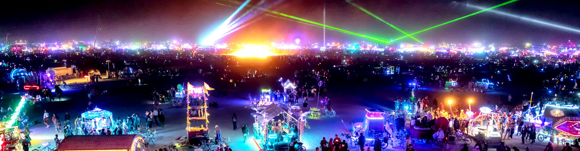
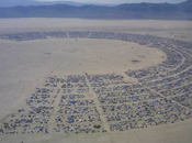
Burning Man turned seventeen in 2002, and everyone seemed to agree that this was a very good year. In fact, it may have been the best year yet. Ample springtime flooding smoothed the surface of the playa in 2002 and restored the burnished fractal crust of former years. Warmer nighttime temperatures allowed participants to rove across the surface of this fossil seabed as if drifting on a Gulf Stream current, and our theme, The Floating World, did much to further this impression.
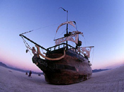 The prospect of imaginary seas produced a record catch of art works in 2002. Not only did we place more installations on the playa than in previous years, but participants created many more art cars in forms as varied as submersibles, a full-scale sperm whale, and, perhaps most startling in its amazing improbability, a perfect copy of a 17th-century Spanish galleon. The sheer abundance of such projects leant a sense of mise en scené to the event, a charm made all the more evocative by the knowledge that so many people had independently joined together in creating it.
Nor does evidence of participation end with the wonderful art. In 2002, our citizens continued to demonstrate a refined civic spirit. The official BLM inspection of our event site, for example, yielded a total 3 square feet of MOOP (matter out of place) when spread out upon a flat surface. This meager collection was the result of completion of three full transects of our space, and should be compared to the allowed standard of 5 square feet per single transect. This evidence of stewardship set a record, and this could not have been achieved without the conscientious help of our participants. Finally, one last record must be mentioned. On the final day of our event, when we computed the number of people who had passed through our gates, we discovered that 29,085 participants had become citizens of our temporary city. That peak population was reached on Saturday afternoon.
 More art, good weather, and a larger population are only the most apparent aspects of the growth of Burning Man. Behind the scenes and beyond the borders of Black Rock City, a much more significant story of growth will be told in this report. In 2002, our regional contact program rapidly expanded. As of this writing, nearly 70 regional representatives have been qualified. Our efforts are now focused on developing this network into a nationwide organization. As part of this new mission, a group of Burning Man organizers traveled to New York City in April 2002 to visit our fastest growing regional center. At Cooper Union, Larry Harvey delivered an address entitled Viva Las Xmas. In it he explained, “We’ve only made our city as large and civic as it is in order to create a sufficiently persuasive model
. I want it to feel like a complete model of civilization so that people can go back home with the confidence that they can change the world that they don’t have to be defined by the context that surrounds them that they can define their world by the vision that’s within them [and] share this vision with other people.” This quote expresses our intention to apply the values learned at Burning Man to the much wider world of daily life. In the coming year, we plan to provide our regional contacts with many new tools and resources, such as a “Film Festival in a Box” and a series of extranet-based communication tools, that will help participants create interactive projects in their local communities.
More art, good weather, and a larger population are only the most apparent aspects of the growth of Burning Man. Behind the scenes and beyond the borders of Black Rock City, a much more significant story of growth will be told in this report. In 2002, our regional contact program rapidly expanded. As of this writing, nearly 70 regional representatives have been qualified. Our efforts are now focused on developing this network into a nationwide organization. As part of this new mission, a group of Burning Man organizers traveled to New York City in April 2002 to visit our fastest growing regional center. At Cooper Union, Larry Harvey delivered an address entitled Viva Las Xmas. In it he explained, “We’ve only made our city as large and civic as it is in order to create a sufficiently persuasive model
. I want it to feel like a complete model of civilization so that people can go back home with the confidence that they can change the world that they don’t have to be defined by the context that surrounds them that they can define their world by the vision that’s within them [and] share this vision with other people.” This quote expresses our intention to apply the values learned at Burning Man to the much wider world of daily life. In the coming year, we plan to provide our regional contacts with many new tools and resources, such as a “Film Festival in a Box” and a series of extranet-based communication tools, that will help participants create interactive projects in their local communities.
One consequence of our expanding mission in 2002 was a need for more office space. We had begun to outgrow our home of two years: two small units in an office court located near Hunters Point in San Francisco. The rampant speculation that fueled the dotcom boom in San Francisco in the 1990s disappeared last year and this change also emptied many buildings. As a result, commercial rental rates began to plunge. This spring we took advantage of this opportunity and began a search for a new home. Like tiny mammals prowling through the bones of dinosaurs, we inspected many different types of spaces. (We even stopped along the way to explore a firehouse complete with a brass pole!) Finally, at what seemed the last minute, we discovered what we had been looking for. Our new office occupies 10,000 square feet, twice the space of our former location, and even better, it rents for exactly the same price. We now have the capacity to hold large meetings, a feature that’s essential to any volunteer-based organization. More importantly, we really love this place. It is filled with art, light streams in from skylights and from three sides of our building. It is dominated by a large open area at its center. Furnished with couches, plants, and sculptures, this central court is now a crossroads for our staff and our community.
 During the first months of this year, we have also begun to plan many improvements to Black Rock Station, our 200-acre property in Nevada, this is the staging area for our event. In order to comply with county regulations, we have adopted a long-term plan that will satisfy requirements of four Washoe County special use permits. This project will allow us to realize a long cherished goal. In the near future, we hope to offer artists and theme camps secure, fee-based dry storage near our event site. This will allow participants to build each year on what they’ve built before.
Last year’s AfterBurn report was the first of its kind, and it met with a very enthusiastic response from participants. Many frequently heard questions were addressed. Who is the mysterious LLC? How is Burning Man governed? How do volunteers participate during the event and throughout the year? What are our future plans? What is our income, and what do we do with it? This report will update our replies to many of these questions, and we intend to make the AfterBurn report an annual project.